


What is Traversing in Surveying
The Traversing can be described in the following points;
- The definition of traverse is “passing across.” It refers to “determining the lengths and directions of consecutive lines” in surveying.
- The relative directions of the lines are measured with a compass, theodolite, or chain, and linear measurements are taken with tape or chain.
- The essential two-dimensional data for calculating the land area and delivering horizontal control comes from direction and distance measurement.
- Combined with results from a level network at the exact location, this data can depict a slice of Earth’s surface in three dimensions.
- Reconnaissance (choosing, marking, and referencing stations), details, and booking field notes are part of the traversal process.
- A general traverse is run to locate the features already existing in the area to be surveyed or to establish points or lines by predetermined measurements.
What is Surveying
Surveying is the process of figuring out where different things on, above, or below the earth’s surface are with each other by taking direct or indirect measurements and then drawing them on a piece of paper called a plan or map.
Surveying is the science and art of taking all the necessary measurements to find out where points or physical and cultural details are with each other above, on, or below the surface of the Earth and drawing them in a way that can be used, or to find out where points or details are.
Definition of Traversing
A traverse is a set of connected lines whose lengths and directions must be measured. Traversing is the surveying process used to find these lengths and directions. In general, chains are used to measure length, and a compass or theodolite is used to measure the direction of traverse lines.
Traversing
This article discusses the different kinds of traverse and how to do it with Theodolite
Types of Traverse
There are two main types of traverse
- Open Traverse
- Closed Traverse
Open Traverse

When a traverse starts at one point and ends at another, as shown in the figure, it is called an open traverse. You can also call open traverse “unclosed traverse.” It can be used to measure roads, coastal lines, etc.
Closed Traverse
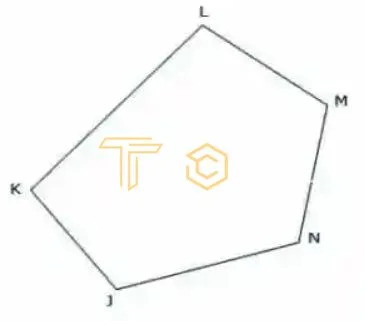
As shown in the figure, a traverse is said to be closed when it forms a closed circuit. In this case, the traverse’s starting and ending points are identical. It is appropriate for surveying the boundaries of ponds, sports fields, forests, etc.
Methods of Traversing
The traversing is done in four different ways, classified based on the survey instrument used. The methods are as follows.
- Chain Traversing
- Compass Traversing
- Theodolite Traversing
- Plane Table Traversing
In this Article, We discuss Traversing with a Theodolite with Differents methods
Theodolite Traversing
In the case of theodolite traversing, the chain or stadia method is used to measure length, and the theodolite is used to measure angles. The magnetic bearing of the first traverse line is measured using a theodolite, and the magnetic bearings of the other sides are calculated based on that magnetic bearing. Compared to other ways, this one works very well.
In Theodolite traversing the fieldwork consisting of the following steps
- Reconnaissance
- Selection, marking, and referencing of station
- Running of survey lines
- Picking up the details
- Booking of field notes is much the same as for compass
- For linear measurements, then steel tape is generally used
The direction of Traverse lines
The methods by which the relative directions of the lines of a traverse may be determined are
- By the measurement of angles between successive lines.
- By the direct observation of the bearings of the line
The former is generally used for long traverses, or for which high precision is required, while the latter is used for short traverses where great precision is not required like topographical surveys
In the first method, the angles between successive lines were measured, and the bearing of the initial line was observed. The bearings of the remaining lines are then calculated from the observed bearing and the measured angle.
Measuring Angles
The angles measured at the different stations may be.
- Included Angles
- Direct Angles or angles to the right
- Deflection Angle
Direct Observation of Angles
There are three methods for direct observation of angles are given below;
- Traversing by the method of included angles
- Traversing by the method of Direct angles
- Traversing by the method of Deflection angles
Traversing by the method of included angles
This method is mainly used in land surveying where great accuracy is required; it is invariably used as the angles can be measured by the method of repetition in any degree of precision. In this method bearing of the initial line and the included angles of a traverse are measured.
In closed traverse, the angle measured is either interior or exterior according to the traverse being run in a counter-clockwise or clockwise direction, as shown in fig; below. It is, however, customary to run a closed traverse in a counter-clockwise direction
Procedure of Traverseing
- In running the traverse ABCDEFGH, the theodolite is set up over the first station A, and the bearing of line AB is observed, as already explained.
- The angle HAB is then measured by taking a backsight on the preceding station H and foresight on the forward station B.
- Turning the telescope clockwise, both verniers are then read.
- This means that the two vernier readings give the required angle HAB.
- Face-left and face-correct observations should be made to eliminate instrumental errors.
- The theodolite is then moved to each of the successive stations’ BC etc., and the angle ABC, BCD, etc., are measured similarly.
- The line AB, BC, etc., are measured with the tape or chain, and the offsets necessary to locate the boundary and other details are taken in the usual way and recorded in the field book.
- Where great accuracy is required, the angles should be measured by repetition, as already described. The angular observation is recorded in tabular form as given below:
Locating Details
On nearly all theodolite surveys, especially in city surveys, the details, such as the frontage of buildings, distant and inaccessible objects, etc., are located from transverse lines with the transit and tape. The following angular methods are in most common use.
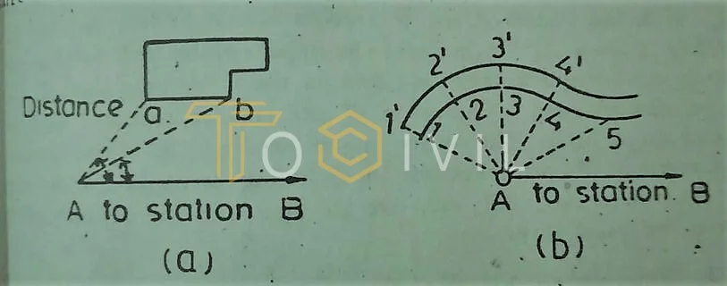
i. Locating by angle and distance from transit station
In this method, the transit is set up at station A, and the angle between the transverse line AB and the corners of the building, such as AB, etc., are measured, and the corresponding distance AB, etc. Curves of large radii or irregular curves are located by angles and distances. For each angle, 2 points are located by measuring the distances from transit station A.
ii. Locating by angle and distance from another station
This method is proper when the direct measurement of the distance from the transit station at which the angle in the object is measured is not possible, growing to some intervening obstacle. In such a case that transit is set up at another station b, the angle between the transverse line ab and the corner f of the building is observed, and the distance bf is measured.
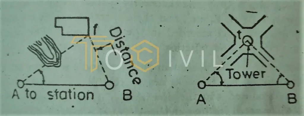
iii. Locating by angles from two stations
Illustrate the method of locating distant or inaccessible objects visible from at least the transit station. The transit is set up at the transit station a, and the angle to the object, such as t, is measured. Similarly, the angle to t is measured on another transit station b. In this method, no linear measurements except those of the transverse lines are required.
Traversing by the method of direct angles
This method is mainly used on open traverses. To run and open travels, theodolite is set up at the starting station a, and the bearing of line ab is observed. The theodolite is then moved to be with the vernier a set to zero, a backsight is taken on the presiding station a. Unclamping the upper plate and turning the telescope clockwise, a foresight is taken on the following station c, and both verniers are read. The mean of the vernier readings gives the required angle ABC. The other angles are read in a like manner. The traverse angles are checked by doubling. The lines AB and BC etc., are changed, and the necessary offsets are taken the usual way.
Traversing by the method of deflection angles
This method is chiefly employed on open traverses. It is most suitable when the survey lines make small deflection angles with each other, as in the case of surveys for roads, railways, canals, and pipelines. Suppose it is required to run a traverse from station A. Theodolite is set up at station a, and the bearing of line ab is observed.
The instrument is then moved to station be, and a backsight is taken on with the vernier set to zero. The telescope is transitive, and foresight is taken on c by releasing the upper played and turning the telescope clockwise. Both verniers are then read, and the mean of these readings gives the deflection angle of BC from AB. The direction of its measurement is carefully noted in the field book. The theodolite is then set up at each successive station C D E etc., and the deflection angles are observed as described and recorded in the field book.
The routine of running survey lines and setting is the same as already explained. It must be remembered that in this method that, deflection angles are measured to the right or the left of the back line produced, and the direction of their measurement must be very carefully noted in the field book to eliminate the error of adjustment and possible mistakes.
More Articles
FAQ’s
What are the 3 main parts of theodolite?
It is essential to know what each part of a theodolite does. The parts should know how to work together. Without regulation, the parts can’t be put together right. Theodolite is made up of a few main parts, like Telescope. Vertical circle. Index frame. It’s a main part of the theodolite.
Which instrument is used in traversing?
In general, chains are used to measure the length of traverse lines, while a compass or theodolite is used to measure the direction. Nowadays Total station technique (Electrical Surveying Machine) is used to measure the direction, length, and angle. It is more accurate than Compass or theodolite.
Which method of traversing is more accurate?
Coordinate method: In this method, the coordinates of the survey stations are used to plot their locations. It is the easiest and most accurate way to plot traverses or any other sizeable horizontal control system. Total station and theodolite are used for this method. A total station is more accurate.
What is the advantage of traversing by theodolite?
Compared to other layout tools, theodolites with optical instruments are better. They can measure more accurately; a digital electronic theodolite automatically reads horizontal and vertical angles. It removes the need to read scales on graduated circles by hand, which removes the chance of making a mistake.
What is traditional traverse method?
Using a transit or theodolite, the internal, external, and deflection angles were turned for the traverse method. At each point along the boundary, measure the distances between each point with a chain or electronic distance meter (EDM). At the very least, this method took much time and was hard to do.