


Plane Table Surveying
Plane Table Surveying can be defined as:
“Plane Tabling is a graphical method of surveying in which the field work and plotting are done simultaneously. It is most suitable for filling in the details between the stations previously fixed by triangulation or theodolite traversing. It is particularly adapted for small-scale or medium-scale mapping in which great accuracy is optional, as for topographical surveys.”
Methods of Plane Table Surveying
There are four methods used in plane table surveying.
- Radiation
- Intersection
- Traversing
- Resection
Radiation Method in Plane Table Surveying
In this method of plane table surveying, the point is located on the plan by drawing a ray from the plane table station to the fact and plotting to scale along the beam the distance measured from the station to the end. The method is suitable for surveying small areas which can be commanded from a single station. It is chiefly used for locating the details from stations, which other forms of surveying, such as triangulation or transit-tape traversing, have previously established.
Procedure of Radiation
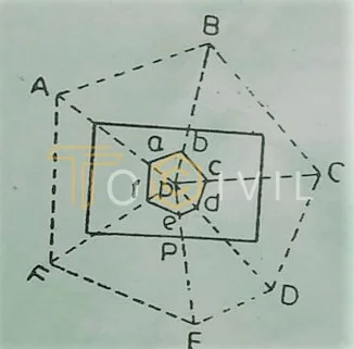
- Select a point P so that all points to be located are visible from it.
- Set up the table at P and clamp the board after leveling it.
- Select a point p on the sheet so that it is precisely over station P on the ground using a U frame. The point represents the sheet the instrument station P on the floor.
- Mark the direction of the magnetic meridian with the help of the compass (trough or circular) in the top corner of the sheet.
- Centering the alidade on p, sight the points A, B, C, etc., and lightly draw rays along the fiducial edge with a chisel-pointed pencil.
- Measure the distances PA, PB, PC, etc., from P to the various points with the chain or tape or by stadia and plot them to scale along the corresponding rays. Join points a, b, c, etc., to outline the survey.
Care must be taken to see that the alidade is touching the point p while the sights are being taken. To avoid confusion, the various rays should be referenced. The fieldwork can be checked by measuring the distances AB, BC, CD, etc., and comparing them with their plotted lengths ab, bc, cd, etc.
Intersection Method in Plane Table Surveying
In this method of plane table surveying, the point is fixed on the plan by the intersection of the rays drawn from the two instrument stations. The line joining these stations is called the baseline. The method requires only the linear measurement of this line.
The method commonly employed for locating:
- The detail
- The distant and inaccessible points
- The broken boundaries
- The rivers
- The issues which may be used subsequently as the instrument stations. It is suitable when it is difficult or impossible to measure distances, as in the case of the survey of a mountainous country. It is also used for checking distant objects
Procedure
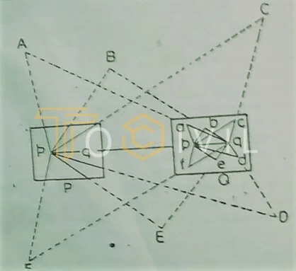
- Select two points, P and Q, in a commanding position so that all points plotted are visible from both P and Q. The line joining the stations P and Q is known as the baseline.
- With the table set up and leveled at P, select a suitable point p on the paper so that it is over the instrument station P’ on the ground, and mark the direction of the magnetic meridian using the compass.
- With the alidade pivoted on point p, sight the station Q and other objects A, B, C., etc., to be located. And draw rays along the fiducial edge of the alidade towards Q. A, B, C., etc.
- Measure the distance from P to Q. accurately with the steel tape and set it off to scale along the ray drawn to Q, thus fixing the position of 9 on the sheet.
- Shift the table and set it up at Q. Centre the table so that point q is directly above point Q on the ground and level it.
- Place the alidade along qp, and after orienting the table by backsighting on P., clamp it.
- With the alidade touching q, sight the same objects and draw rays. The intersections of these rays with the corresponding rays drawn from p determine the positions of the objects A. B. C, etc., on the sheet.
Care should be taken to avoid very acute or obtuse intersections, the extreme limits for the intersection angles being 30° and 120°.
Alternative Method of Intersection
- Choose two stations, P and Q, and Measure the baseline PQ. Accurately with steel tape, plot it to scale on the sheet in a suitable position.
- Set up the table at P and center it so that the point p is vertically over the station P on the ground to level the table
- Keeping the alidade along the line pq, orient the table by turning the board until the ranging rod at station Q is sighted. And then clamp it.
- Mark the magnetic meridian’s direction with the compass’s aid.
- With the alidade pivoted on p, sight the objects A, B, C, etc., to be located, and draw rays along the fiducial edge of the alidade.
- The rest of the procedure is the same as in steps 5 to 7 in the preceding method.
Traversing Method in Plane Table Surveying
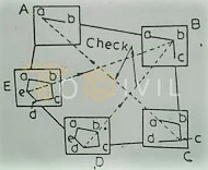
This method of plane table surveying is similar to that of compass or transit traversing. It is used to survey lines between stations previously fixed by other forms of surveying to locate the topographical details. It is also suitable for the survey of roads, rivers, etc.
Procedure
- Select the traverse stations A, B, C, etc.
- Set up the table at A. Select the point suitably on the sheet. Center and level the table when the board is clamped.
- Mark the direction of the magnetic meridian on the sheet.
- Centering the alidade on sight, the ranging rod at B draws a ray along the beveled edge of the alidade.
- Measure the distance AB with the chain or tape, and lay it off to scale on the ray drawn towards B., thus fixing the position of b on the sheet, representing station B on the ground.
- Locate the surrounding detail by radiation or offsets taken in the usual way and the distant objects by intersection.
- Shift the instrument and set it up at B. Having centered and leveled the table, orient it by backsighting on A with the alidade along ba, then clamping the board.
- With the alidade pivoted on b, sight station C and draw a ray along the fiducial edge of the alidade.
- Measure the distance BC with the chain or tape, and set it off to scale on the ray drawn to C to fix the point c on the sheet. The nearby detail is located as before. (10) Continue the process until all the remaining stations are plotted
In-plane table surveying, the work can be checked at any station by taking sights to two or more preceding stations visible from the station occupied. When no station is visible, any well-defined points, such as a corner of a building that was previously fixed, can be used for checking. If the traverse is closed, the work can be restricted by plotting the starting point from the traverse’s last station and finding the closure error. The closing error is adjusted graphically as in compass traversing.
Resection Method in Plane Table Surveying
This method of plane table surveying is used for establishing the instrument stations only. After mixing the stations, details are located either by radiation or intersection. The characteristic feature of resection is that the point plotted on the plan is the station occupied by the plane table surveying.
Procedure
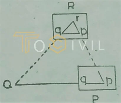
- As in the intersection method, select a baseline PQ on the ground. Measure it accurately with the steel tape and plot it to scale on the sheet as pq in a suitable position.
- Set up the table at P. Centre it so that p is vertically over P and level it.
- Place the alidade along pq, orient the table by turning the board until the signal at Q is bisected, and clamp it.
- With the alidade touching p, sight the station R which is to be located by resection, and draw a ray along the ruling edge of the alidade. Mark the point along the beam by estimation.
- Shift the table and set it up at R with r over R. Orient the table by taking a backsight en P and clamping it.
- With the alidadé centered on q, see the station Q and draw a ray. The point of intersection of this ray and that previously drawn from p gives the required end 7.
- Continue the process to establish other station points.
This method of plane table surveying described above is called the back ray method, as it is necessary to draw a ray from the preceding station to the station to be occupied by the instrument. This method of plane table surveying requires the previous selection of the instrument station. It is a particular case of resection. Though inevitable in this method, errors of centering will not affect the accuracy of work since resection is used for small-scale work only.
More Posts
FAQ’s
What is two point method in plane table surveying?
The two-point problem consists in locating the station occupied by the plan table on the plan. The observation of two well-defined points visible from the instrument station and whose positions have already been plotted on the graph is chosen. Then, a new station at the required place is established by perfectly bisecting these points.
What is three-point method in plane table surveying?
Three points and their positions in the field are known in this condition. The plane table is positioned so that all three points are visible. So, by sighting those three points, we can find the location of the equipment.
Which method of plane table survey is most accurate?
Method of trial and error or Lehman’s method:
Because it is very accurate, this method is mostly used in field measurements. A plane table’s position is estimated using judgment. Trial and error have reduced this tringle to a point.
This method is the quickest and most accurate for solving three-point problems in plane tabling resection.
What are the six types of survey?
There are several types of surveys, but six common types are:
1. Cross-sectional survey 2. Longitudinal survey 3. Cohort survey 4. Panel survey 5. Cross-cultural survey 6. Online survey
What is EDM in surveying?
EDM is an abbreviation for Electronic Distance Measurement. EDM is a method of measuring distances between two points in surveying that uses electronic equipment. Electronic distance measuring devices determine the distance between two points using electromagnetic waves such as light or radio waves.